Modern field operations require more than simple voice communication. Whether the mission involves emergency response, public safety, counter-terrorism, industrial security, large-site protection, or tactical field coordination, teams need a communication foundation that can connect command centers, front-line personnel, radios, video sources, maps, mobile terminals, and unmanned equipment into one operational workflow.
A converged command communication platform is designed to support this requirement. It integrates wireless communication, video streaming, GIS-based situational awareness, radio networking, mobile collaboration, task dispatch, and cross-terminal access. The goal is to create a full-chain command and control system that supports reconnaissance, decision-making, dispatch, execution, feedback, and review.
Operational Background and Communication Pain Points
In complex field environments, communication is often fragmented. The rear command center may use a fixed command platform, the forward command post may rely on temporary equipment, field personnel may use handheld radios or mobile devices, and UAVs or cameras may generate independent video streams. If these systems are not integrated, commanders must switch between multiple platforms to understand the situation and issue instructions.
This fragmentation directly affects response efficiency. Video information may not be synchronized with map positions, radio users may not be visible on the command interface, task instructions may be sent through separate channels, and field feedback may not return to the command center in time. During fast-moving operations, this delay can weaken situational awareness and reduce the accuracy of command decisions.
A better approach is to build a communication and command foundation that connects people, equipment, maps, video, tasks, and communication channels together. This allows the entire operation to move from isolated tools to a coordinated digital workflow.
Solution Positioning: A Unified Field Command Foundation
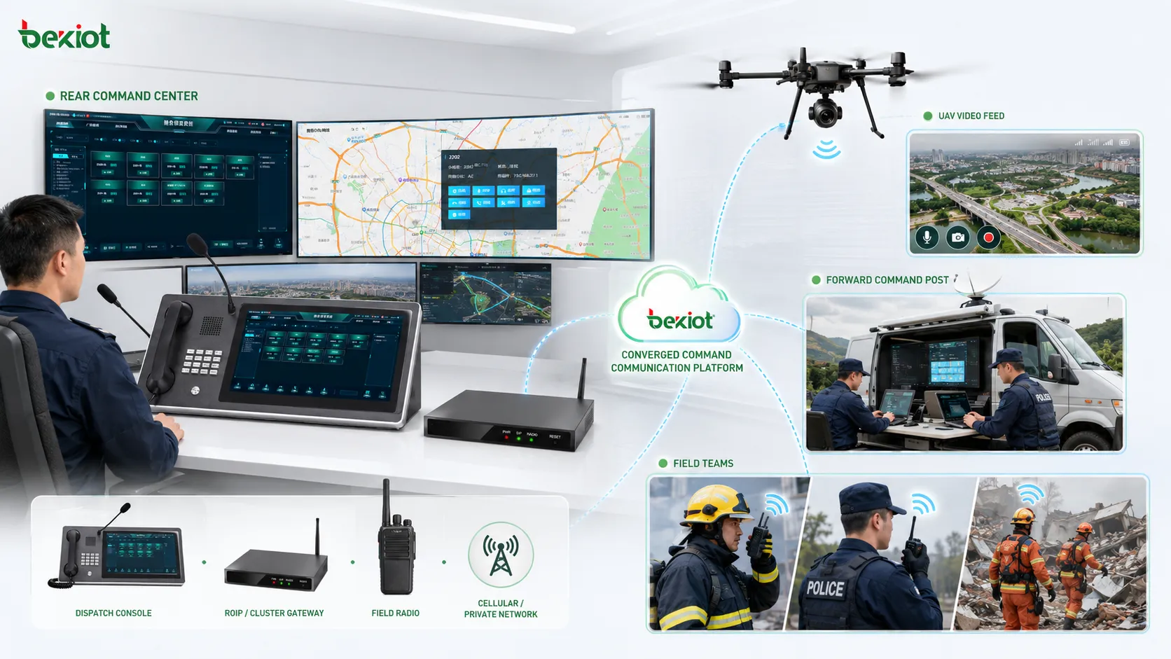
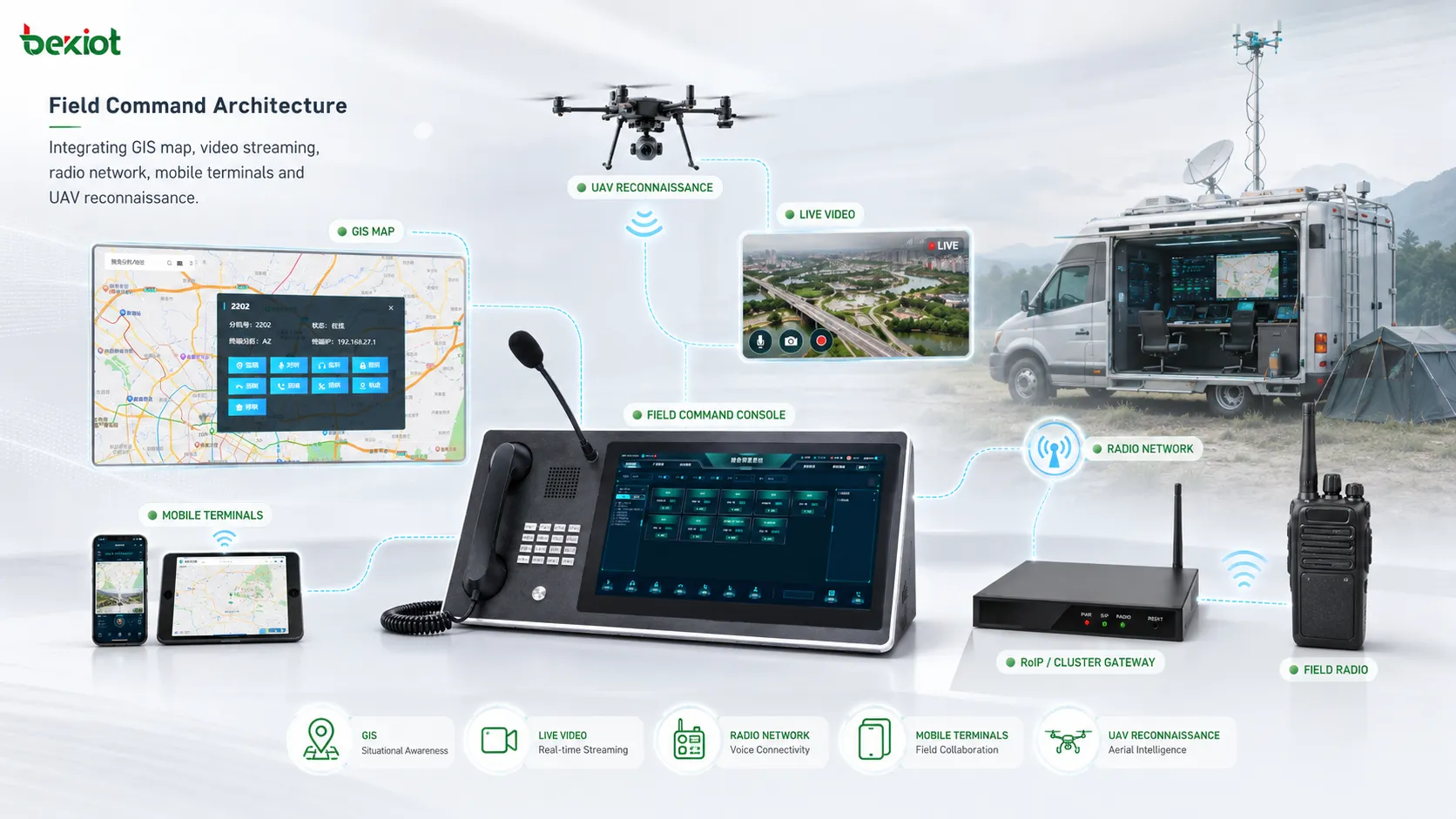
The solution is positioned as a converged command communication platform for field teams and command centers. It can support a multi-node architecture that includes the rear command center, forward command post, individual field operators, UAV systems, radio networks, and mobile terminals.
Instead of treating voice, video, mapping, and task dispatch as separate systems, the platform combines them into one operational environment. This helps commanders see field positions, receive live video, manage communication groups, assign tasks, track routes, and coordinate field execution from a unified interface.
Related Solution: Converged Communication System for Emergency Command
For emergency communication projects, Becke Telcom can provide system planning support for dispatch platforms, SIP communication, radio interconnection, emergency broadcasting, video linkage, and field command integration.
Architecture from Command Center to Field Teams
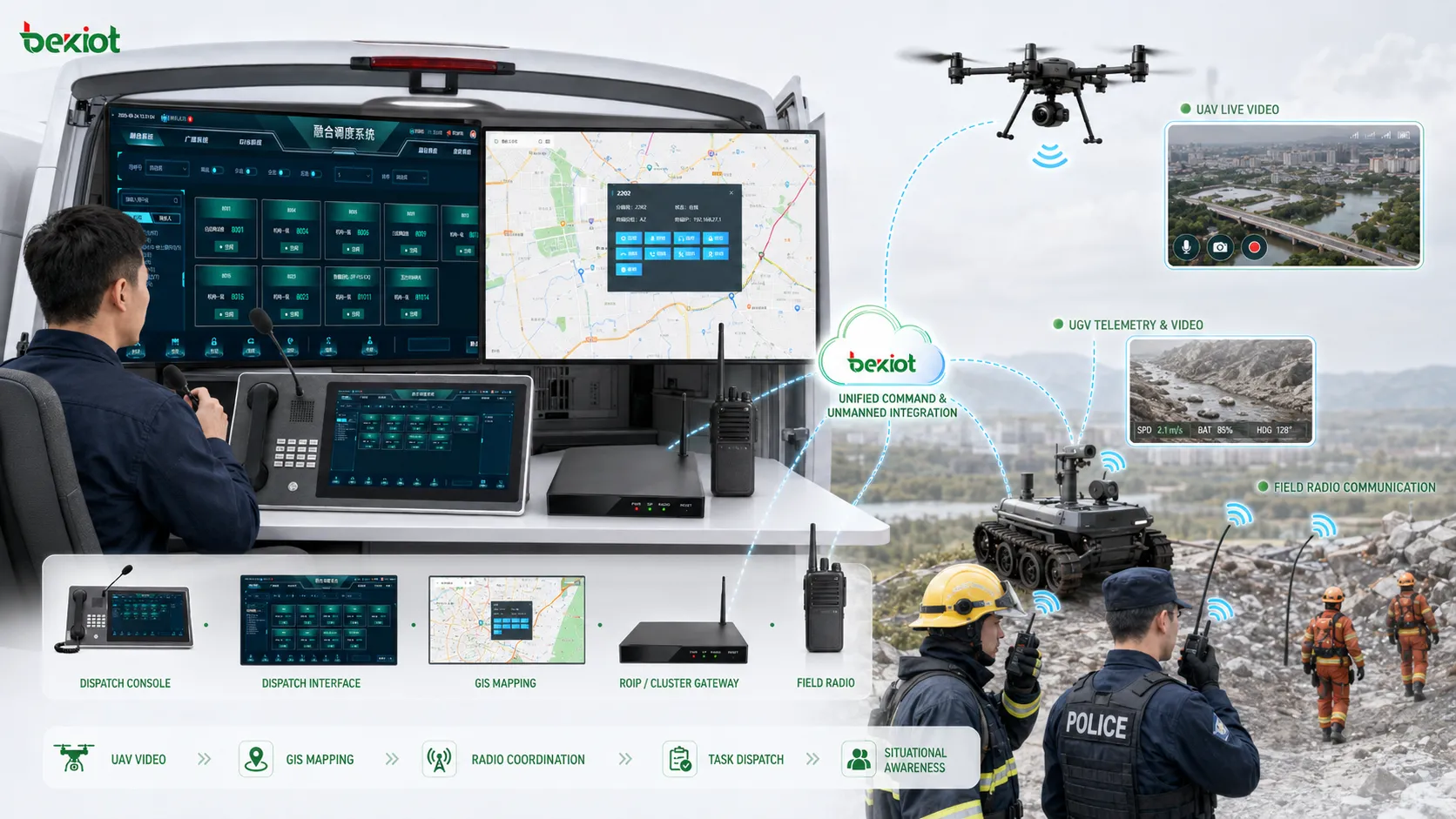
A typical deployment includes a rear command center, a forward command node, field personnel terminals, UAV video sources, radio communication equipment, GIS map services, task dispatch modules, and management tools. These components work together to support command decisions and field execution.
The rear command center is responsible for overall situational monitoring, cross-team coordination, expert support, and mission supervision. The forward command node is closer to the operation area and can support real-time dispatch, field video access, temporary group communication, and rapid response coordination.
Field personnel can use mobile terminals or radio devices to report position, send messages, receive tasks, view assigned routes, and provide feedback. UAVs, mobile cameras, and other video sources can provide live reconnaissance information, while GIS maps display team locations, routes, marked points, and operational areas.
Video Streaming and Visual Intelligence
Live video is one of the most important sources of field intelligence. The platform can support standard RTSP video stream access, allowing real-time video from cameras, UAV systems, mobile video terminals, or other field devices to be brought into the command environment.
To adapt to different network conditions, the platform can support main-stream and sub-stream switching, as well as UDP and TCP transmission adaptation. This helps maintain video availability when bandwidth, latency, or network stability changes during field operations.
The video layer should also support recording, real-time screenshots, playback, and review. These functions are important for event analysis, command review, evidence retention, training, and post-mission reporting. For projects with diverse camera resources, SDK-based adaptation and multi-vendor camera compatibility are also valuable.
Smarter Control of Radios and Camera Resources
Radio and camera management is not only about device access. In real command scenarios, the platform should support logical grouping, remote configuration, online status display, and operational visibility. Radio devices can be grouped by role, team, region, or mission type so that commanders can manage them more efficiently.
Camera resources should be easy to identify and access. Automatic device recognition can reduce manual binding work and simplify field deployment. When a camera or radio joins the system, the command team should be able to understand its status, location, and connection condition quickly.
Remote parameter configuration is also important. In field environments, it is not always practical to physically adjust every radio, camera, or terminal. Remote configuration and online maintenance functions help reduce deployment complexity and improve operational continuity.
GIS-Based Situational Awareness
GIS mapping is the visual foundation of field command. The platform can integrate both online and offline map engines, allowing teams to maintain map-based operation even when network conditions are unstable or external map services are unavailable.
With GIS integration, commanders can view field positions, task points, movement routes, target areas, and operational zones on a shared map. Custom markers can be used to represent different teams, locations, objects, incidents, or tactical elements. Picture-in-picture display can also help combine map view and video view into a wider operational picture.
When radio GPS positioning data is integrated, field personnel can be displayed on the map in real time. This supports team distribution visualization, route tracking, position sharing, point navigation, and more accurate dispatch decisions.
Lightweight Team Collaboration
Field operations require fast communication between individuals, teams, and command levels. A lightweight instant communication architecture can support text, images, group communication, point-to-point messaging, and online status awareness.
This reduces the dependence on voice-only communication. Team members can exchange photos, short messages, task notes, and location-related information when voice communication is not enough or when the environment is noisy.
Custom group creation is useful for mission-based coordination. For example, a temporary group can be created for a rescue unit, patrol group, technical team, security team, or unmanned equipment support group. This keeps communication focused and reduces unnecessary information interference.
Task Dispatch and Route Guidance
Task dispatch is a key part of command execution. The platform can support map-based task points, task route marking, classified task management, and color-coded route planning. Different task routes can be displayed in different colors so that commanders and field personnel can clearly understand mission priorities and movement directions.
Permission-based task visibility is also important. In some operations, only assigned personnel should be able to view specific task points, routes, or mission details. This supports information control and reduces unnecessary exposure of sensitive operational data.
Built-in navigation logic allows the command side to plan a route while the field terminal automatically receives the assigned task and follows the route guidance. This creates a more complete workflow from command planning to front-line execution.
A field command system becomes more valuable when communication, mapping, video, and task execution are connected as one operational chain.
Cross-Platform and Multi-Terminal Compatibility
Command systems must work across different terminal environments. The command and control side may need to support desktop operating systems such as Windows 7, Windows 10, and Windows 11, while the field mobile side may need to support Android and HarmonyOS environments.
Cross-platform compatibility helps organizations deploy the system on command workstations, rugged tablets, mobile terminals, and portable field devices. A lightweight installation approach can also reduce deployment cost and make field adoption easier.
In practical projects, compatibility should not only focus on operating systems. It should also cover screen layout, control responsiveness, map performance, video playback, network switching, device access, and field usability under pressure.
Advanced Capabilities for Real Operations
In addition to basic communication and mapping functions, the platform can support advanced modules such as facial recognition, network topology visualization, video playback, intelligent configuration, and structured target reporting.
For tactical or high-risk operations, field personnel may need to report target coordinates, altitude, longitude, latitude, status, attributes, and other structured information. Standardized reporting helps the command center analyze the situation more accurately and share information across teams.
The system can also support fire guidance, strike task submission, target information synchronization, and mission-related parameter management in specialized scenarios. For civilian emergency and industrial safety environments, similar logic can be adapted to rescue target marking, hazard reporting, repair task assignment, and resource coordination.
Extending the System with Unmanned Equipment
Modern field operations increasingly involve unmanned platforms. A practical command communication foundation should provide open access capability for UAVs, unmanned ground vehicles, robotic platforms, portable radios, airborne radios, and other field equipment.
By integrating people, communication devices, unmanned platforms, video feeds, and GIS maps, the system can create a more complete human-equipment collaboration model. This is especially useful for dangerous environments where personnel should not enter immediately, such as disaster zones, industrial accident areas, fire scenes, hazardous material sites, and complex urban incidents.
Unmanned equipment can provide reconnaissance, video feedback, route observation, target confirmation, and environmental information. When this data is connected to the command platform, commanders can make more informed decisions and assign tasks with better context.
Recommended Deployment Structure
| Layer | Main Components | Operational Role |
|---|---|---|
| Command layer | Rear command center and forward command post | Supports decision-making, coordination, monitoring, and mission control |
| Communication layer | Radio networks, mobile terminals, SIP communication, and group messaging | Connects command personnel, field teams, and mobile users |
| Video layer | RTSP cameras, UAV video, mobile video terminals, recording, and playback | Provides live visual intelligence and post-event review capability |
| GIS layer | Online maps, offline maps, GPS positioning, route rendering, and point marking | Builds a real-time map-based operational picture |
| Task layer | Task points, route planning, permission control, and mobile task reception | Links command planning with field execution |
| Extension layer | UAVs, unmanned vehicles, robotic platforms, and external equipment | Expands reconnaissance and field collaboration capability |
Application Scenarios
This solution is suitable for emergency response, public safety command, counter-terrorism operations, special event security, large industrial site protection, transportation emergency management, forest fire prevention, port and airport security, energy facility protection, and large campus or park safety operations.
In emergency management, the platform can connect rescue teams, video sources, radio groups, GIS positions, and command staff into one workflow. In industrial environments, it can support security patrols, hazardous area monitoring, maintenance dispatch, emergency repair, and incident response. In public safety scenarios, it can support temporary command posts, mobile teams, patrol units, UAV reconnaissance, and cross-team coordination.
The same architecture can also be extended to large venues, logistics parks, urban operation centers, utility networks, and railway or highway operation environments where field teams and command centers must work together in real time.
Planning Points Before Implementation
Before deployment, organizations should clarify the command hierarchy, field team structure, communication channels, video source types, map requirements, terminal environments, and task dispatch workflow. These factors determine the final system architecture.
Technical planning should also include RTSP stream access, main-stream and sub-stream strategy, UDP and TCP network adaptation, video recording storage, GPS data integration, offline map preparation, device grouping rules, permission design, and mobile terminal compatibility testing.
If the system needs to work with existing radios, cameras, UAVs, dispatch platforms, emergency broadcasting systems, or SIP communication platforms, interface testing should be completed before full deployment. Stable integration is the foundation for reliable field command.
Operational Benefits
A More Complete Command Picture
By combining video, GIS maps, radio positions, task points, and field reports, the command center gains a more complete understanding of the operation. This reduces dependence on fragmented voice reports and improves decision quality.
Faster Field Coordination
Task assignment, route guidance, group messaging, radio communication, and live video can work together inside one platform. This helps reduce repeated communication and speeds up field execution.
Improved Safety for Front-Line Teams
Real-time location display, route planning, visual reconnaissance, and status feedback help commanders understand where personnel are and what risks they may face. This improves the safety and control of field operations.
Better Use of Existing Equipment
The platform can integrate existing radios, cameras, mobile terminals, map resources, and unmanned equipment through standard protocols and adapted interfaces. This helps organizations upgrade their command capability without replacing every device at once.
Scalable System Expansion
As operational requirements grow, the system can be expanded with more video sources, mobile terminals, unmanned platforms, dispatch modules, and data interfaces. This makes it suitable for both small field teams and larger command center deployments.
FAQ
How should an organization choose between online and offline GIS maps?
Online maps are useful when network connectivity is stable and up-to-date map resources are required. Offline maps are better for remote, high-risk, or disconnected environments. Many projects should prepare both options so the system can continue operating when the network changes.
What should be tested before connecting UAV video to the platform?
The project team should test stream format, RTSP access, latency, bitrate, network stability, video decoding, recording, and whether the command platform can display the stream smoothly under real operating conditions.
How can task information be protected in sensitive operations?
Task information can be protected through role-based permissions, assigned-user visibility, encrypted communication, operation logs, and controlled data sharing. Only authorized personnel should see sensitive routes, target points, or mission details.
What is the value of network topology visualization?
Network topology visualization helps administrators understand which devices are online, how links are connected, and where failures may occur. This is useful for maintaining system reliability during long operations or complex deployments.
Can this type of platform support both emergency response and daily management?
Yes. The same platform can support daily patrol, equipment inspection, video monitoring, task assignment, and team communication. During emergencies, these existing workflows can be upgraded into a higher-priority command and response process.